
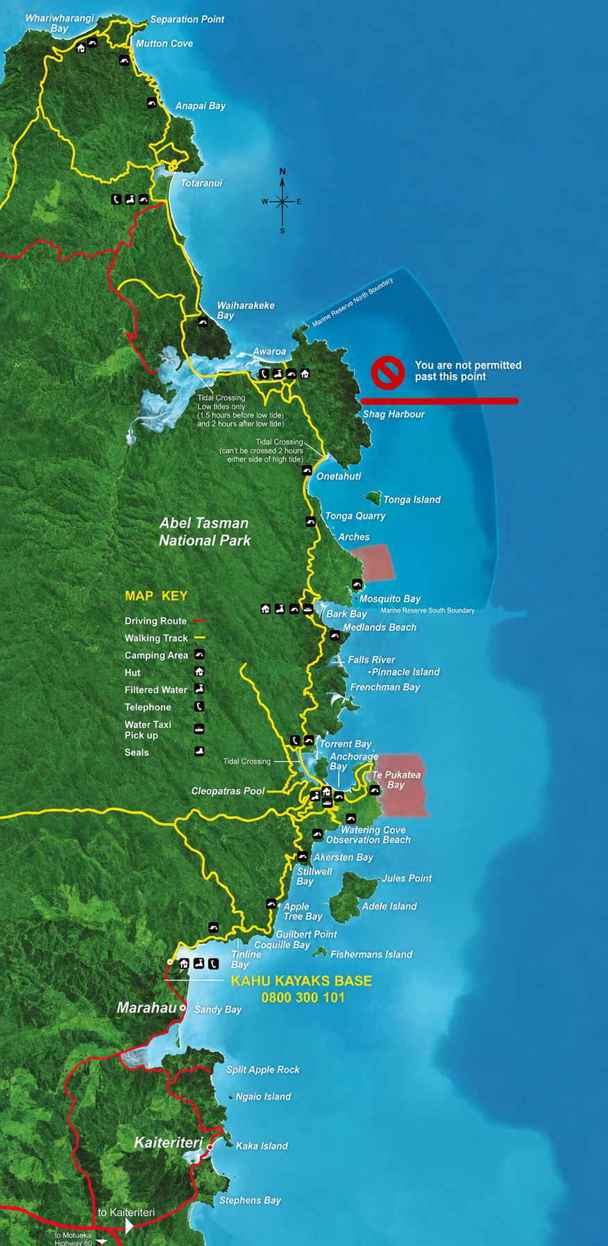
The Abel Tasman makes more sense when you can picture the order of its bays. Use the Kahu map to get familiar with the coastline and talk through the trip you’d like to take. It’s an illustrated planning reference, not a live record of track conditions, permitted access or today’s sea state.
Read the coast from south to north
Start at Mārahau, then find the southern bays, Anchorage and Torrent Bay. Continue north to Bark Bay and Onetahuti, with Awaroa, Tōtaranui and Whariwharangi farther along the coast. Seeing the sequence helps when you’re comparing an out-and-back paddle with a journey that finishes on foot or by water taxi.
The coastline and walking track take different paths. A line across the water is not a walking connection, and a nearby bay may sit below a headland that the track climbs around. Read our Coast Track guide alongside the map when planning a combined trip.
Join up the paddle, walk & pickup
For each stage, ask where you arrive, where you leave and what happens to your gear. A water-taxi symbol does not reserve a seat or confirm that a particular service runs on your date. Confirm the stop, time, luggage and kayak arrangements directly with the relevant operator.
Mosquito Bay is an important exception: DOC says it has no walking access or water-taxi service. Private boat access must be arranged before booking the campsite. For overnight plans, use our campsites and huts guide to check that the map and your reservation describe the same journey.
Keep the kayak route within your briefing
Kahu’s northern freedom-kayak limit is Shag Harbour. Do not plan an overnight kayak camp north of Onetahuti; any onward walking needs its own agreed arrangements. The map shows more coastline than a single hire trip covers. Talk through your chosen route and landing options rather than taking the extent of the drawing as a paddling permission.
Stay together, wear your lifejacket and follow the instructions given at the briefing. Watch weather and sea conditions throughout the journey. Our original map specifically flags Foul Point as exposed to northern and eastern onshore winds; discuss it with the crew before departure. In doubt, don’t go out.
Put a time beside the tidal places
Estuaries can look like simple shortcuts on a map. On foot, Awaroa is a compulsory crossing with a restricted low-tide window and daylight requirement; Torrent Bay has an all-tide alternative. Read DOC’s tide tables and crossing instructions for your date rather than estimating from the drawing.
For a kayak journey, ask how the tide changes your launch, landing and inlet access. Our weather and tides guide brings the relevant official sources together. Leave time for the real journey, including loading and carrying equipment.
The marine reserve is part of the route
Tonga Island Marine Reserve protects a section of the coast and sea. No fishing or shellfish gathering is permitted within it. Keep clear of wildlife, follow current reserve guidance and ask the crew about the boundaries relevant to your trip.
Islands are also sensitive habitat. Seeing a beach on the map does not establish a right to land or camp. Read our beaches, bays and islands guide for the distinctions, and check current DOC access advice before setting out.
Leave the place ready for the next visitor
Use designated toilets, take all rubbish and food scraps out, keep streams clean and camp at your booked site. Check current fire restrictions before cooking or considering a fire. Keep food and gear away from wildlife, and check boats and bags for pests before travelling near the islands.
Before departure, check DOC’s current park information and carry a suitable map and trip information you can use offline. If a detail on this preserved Kahu map differs from current signs, official advice or your briefing, ask the crew to resolve it before you travel.
Reviewed 20 October 2026 against Kahu’s original map and safety copy, current DOC park, tide, campsite and marine-reserve guidance, and Kahu’s freedom-hire limits. The original map asset is preserved unchanged. It is not certified here as a current navigation chart; confirm route details and current conditions before use.